Monday, July 23, 2012

Lorenzo Curve

http://www.unc.edu/depts/econ/byrns_web/Economicae/Figures/Lorenz.htm

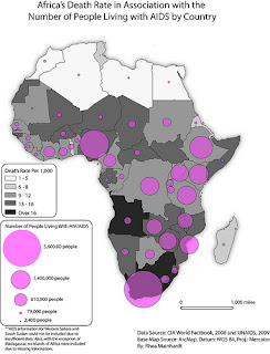
A Lorenzo Curve line graph shows a probability distribution of statistical values and most of the time show the degree of inequality that exists between two varibles. This map show the distribution of the income in reference to the population as a percentage.

Unstandardrized Choropleth Map


A Unstandardrized Choropleth Map is a form of thematic map that depicts data information sets as raw numbers. Instead of is showing the average data it displays the original value. The map above is showing the 2010 3rd quarter county-level police misconduct incidents. Each color interval represents the different raw value data for each area making it a good example of a Unstandardrized Choropleth Map.

Standardized Choropleth Maps

http://www.statcan.gc.ca/pub/92f0138m/2008003/figures/5200001-eng.htm

Standardized Choropleth maps show overall averaged data. So instead of showing the viewer total value, it shows information in a standardized unit, usually in area. Standardized choropleth maps usually are used to show population in form of people per square mile in a state. The map above shows the percentage of population in canada of the age 14 and younger. See how it uses the different shades of green for each state to show the percent of how many people are 14 and younger.

Univariate Choropleth Map

http://www.colocarto.com/custom-thematic-maps.html

A univariate choropleth map is a lot like other choropleth maps except it only displays one variable but still having all the criteria to make it a choropleth map. Its just a simpler map. The map above shows the estimated median household income for 2008 in the United States. The map only displays one variable and uses one shade of color to separate the increases.

Bivariate Choropleth Map

http://proceedings.esri.com/library/userconf/proc99/proceed/papers/pap171/p171.htm

A bivariate choropleth map depicts two different variables on a single map by including two different sets of graphical colors or symbols and combining the different sets of data. The map above does a good job of showing how a bivariate map works, it shows the median house value but at the same time shows the population in 1997.

Range graded Proportional circle map

https://www.e-education.psu.edu/geog486/book/export/html/1796

A range graded proportional circle map is a proportional circle map that uses circles in relation to the different range of data. The data is divided into interval groups and depicted as circles or sometimes other symbols. The different size circles make it easier for the viewer to read the map. The maps above is a good example of a range graded proportional circle map. Its shows the the amounts of motor vehicle deaths in different areas of california. You can see how it makes some symbols larger to show a higher amount of deaths in that area.

Digital Orthopho Quater Quads (DOQQ)

http://www.lib.ncsu.edu/gis/doqq.html

Digital Orthopho Quater Quad maps are created by the USGS. They are digital aerial photos that are have a uniform scale and a resolution of 1 meter. This allows you to use the map directly without any worries of distortion. The photo above shows a aerial infrared DOQQ photo of Johnston County in 1998. You can clearly see its a straight forward photo with no distortion from camera tilt or or the terrain.

Unclassed Choropleth Map

http://www.flickr.com/photos/geminicollisionworks/2108838790/

Unclassed Choropleth maps are a lot like classed Choropleth maps, except with unclassed choropleth maps they don't show average statistics for every color interval. It allows us to have a better idea of the numerical relations between the data in certain areas. The shades of color are proportionally true to the data of each area. This Unclassed Choropleth maps shows the difference in democrats (blue) vs republicans (red) living in the United states. You can see that most places aren't a solid red or blue but a mixture and that because most states are not fully democrats or republicans.  

Classed choropleth map

http://courses.washington.edu/info424/Labs/ChoroplethMap.html

In a class choropleth map it uses a legend to show specific data. It uses intervals to show data for easier viewing. The intervals can vary depending on how the map creator wants to split the intervals. It can be split by natural breaks, quantiles, or equal steps. This map is divided into 6 intervals on the legend depicting data for a one-year forecast change in jobs for the united states from 2009 vs. 2010.

Nominal area Choropleth map

http://my.ilstu.edu/~jrcarter/Geo204/Choro/Tom/

Nominal area choropleth map is a type of choropleth map that is used to show collected nominal data, like population for a example. Here is a map of Florida showing nominal data of the population of hispanic and latinos in different areas. Its uses different shades of green to show population density, making it easier to to display the nominal data.

Sunday, July 22, 2012

DEM Digital Elevation Model

http://www.mapmart.com/Products/DigitalElevationModel.aspx

Digital Elevation Models (DEM) are types of maps that give us a idea of what the elevation of the area looks like. It helps to give a better understanding of what the lay of the land looks like, so we can better understand the rain, wind, and temperature patterns. You can see on the map above the difference between the the plains and the mountains, along with the river that runs between the mountains.

Bilateral graph

http://seekingalpha.com/article/241440-will-october-s-improved-trade-deficit-continue

Bilateral graph shows you more than just one sets of data that overlap one another. It can display both the negative and positive sets of data. This bilateral graph shows the trade deficit of the US of two different years. you can see how the overlap a little in january and it does a good job of giving the viewer a easy look at the difference between the two sets of data.

Population Profile

http://www.ifad.org/operations/regional/pf/aids_1.htm

A population profile is a chart used to show the number of people compared by their age. It can also be used to chart other variables too. The Census uses this a lot to chart the age of the population. This graph shows the population of people in southern and eastern africa that have AIDs and do not have AIDs.

Index value plot

http://www.coastalinarealtyofcharleston.com/Charleston-SC-Real-Estate-Home-Value-Index-Is-Now-Prepared-by-the-College-of-Charleston

A index value plot is used to show absolute numbers and values. Its a lot like a line graph, but it actually corresponds to two variables and measures the index values. This graph shoes the index vaule for the monthly home value index for the college of Charleston.

Parallel Coordinate Graph

http://www.evl.uic.edu/aej/424/kyoung/Training-parallelcoordinate.html

Parallel coordinate graphs are used to display multivariate amounts of data. You can see on the chart above how its uses lines to plot the many different values across the graph. Its show crowd, density, SPF, SC1, and other different data of the many samples.

Stem and Leaf


http://www.bbc.co.uk/schools/ks3bitesize/maths/handling_data/collecting_recording/revise8.shtml

Stem and Leaf plots are a way to display quantitative data in a graphical form. Its uses two columns to split numbers that represent different figures. It the first coulmn goes the first digit and the second digit goes in the second cloumn. It makes it easier to see the mean and different data collected. The graph above show the difference in math grades out of 50. You can see that the three people scored a 17 on the test by looking at the first column and seeing the 1 and going over and seeing the three 7s.

Triangle Plot

http://www.westone.wa.gov.au/toolbox6/hort6/html/resources/depot/hort_file/pyramid/text_alt.htm

A triangle plot is a graph that shows three variables which sum to a constant. It graphically displays the data and ratio of three variables on a triangular graph. Its used a lot in chemistry, mineralogy, metallurgy, and other physical sciences. The graph above is used to show the variables between clay, silt and sand. It shows the different mixtures of the three variables as the combine with each other on the plot.

Histogram

http://www.mathsisfun.com/data/histograms.html

A histogram is a display of data using graphical bars of different heights. Its a good way to show continuous data. A histogram shows tabular frequencies. It can e used to show time intervals, different distributions, etc. The histogram above show the how frequent the different numbers occur and use the bars to easily display the data for viewing.

Climograph

http://climate.gi.alaska.edu/climate/Climographs/ANC.html

A climograph shows the climatic parameters for a certain area. They show monthly averages of the temperatures and predictions. Its makes a easy way to get a quick-view of the climate. The graph above show the climate for Anchorage, you can see easily that august and september are the months that receive the most rain and june through August have the highest temperatures.

Windrose

http://www.climate.washington.edu/climate.html

Windrose is a tool that is used by meteorologists to show the wind's direction and its speed in a particular location. Wind rose compasses use to be found on maps before the compass rose was found on maps. This particular Wind rose compass shows the wind information in Washington State. Its gives you a clear idea of what direction the wind blows and the velocity in blows in that direction.

Digital Line Graph (DLG)


A DLG or Digital Line Graph are maps that show roads, utility lines, boundaries, and other cartographic information on a topographic map. The image above is a map showing DLG data of the water systems of Lake Tahoe and the land that surrounds it. You can see how the red lines are used point out the water ways and the boundaries around the lake.  

DRG - Digital raster map

https://www.e-education.psu.edu/natureofgeoinfo/c6_p6.html

Digital Raster Maps are scanned image of paper USGS maps of the topography creating a digital image on a computer usually in a TIFF. format. They are usually used as backdropped images for other digital maps. This is  digital scan of a partial USGS image of Bushkill, PA.

Friday, July 20, 2012

Box plot

http://blogs.sas.com/content/graphicallyspeaking/2012/04/23/sas-global-forum-monday-update/

A box plot is used to show a set of data that is measured on an interval scale. It shows the central value, the shape of the distribution, the max and the minimum values and even the median. Values outside the maximum and minimum are called outliers. This box plot shows the scale of people  who die from cholesterol. By looking at the values more men die of cholesterol that women.

Isopleth Maps

http://www.stonelions.com/Jacksonville.htm

Isopleth are maps that are connected together by points with a specific constant value. Most of the times they are used to map elevation, pressure, or rainfall amounts. This map shows the contamination of toxic chemicals in Jacksonville FL. You can see how the line connects the 100 points on the map showing the contaminated area.

Black and White Aerial Photography


http://egsc.usgs.gov/isb/pubs/booklets/aerial/aerial.html

    Black and white aerial photography is remote sensing that uses black and white film to take aerial photos of the topography from the air or space. Its a good way to map out land features or land covers. This is a black and white photo of the Amazon Basin. You can see how the black and white make it east to see the hills and mountains in the area.

Thursday, July 19, 2012

Infrared Photography


http://www.aerialarchives.com/Infrared-Aerial-Photography.htm

Infrared photography is used to take photos of the land using special film that is sensitive to a certain portion of the light spectrum. It can be used to see changes in the environment like forest, wetlands, bays, etc. There are also other uses for infrared like finding sites with toxic chemicals or roofs that have been damaged. All of this information can be used for planning or monitoring. This map shows shows a infrared photo of the Sacramento river and its levees. You can see how the photo uses red to show the land around the water.

Cartographic Animations

http://uwacadweb.uwyo.edu/JSHINKER/animations/global/

Cartographic animation maps use moving images or some form of animation to show a data or goal. This type of map can include time, where other maps cannot. These maps are mostly used to show a large change and can either be sped up or slowed down depending on what data is being shown. The map above show the change in heat storage over the months for a whole year. This image shows a clear example of how the heat changes over the months through animation.

Statistical Maps

http://www.policemisconduct.net/npmsrp-2009-preliminary-police-misconduct-statistical-report/

Statistical maps show the different variation in quantity of a value for a certain area. Examples are like population, drug use, average rainfall, etc. This maps shows the number of misconduct incidents in the year 2009 across the United states. The red shows the highest  amounts incidents. This shows a good example of what a statistical map should show.

Proportional Circle Map


 Proportional Circle Maps use circles to represent the portion of a value of data on a map.  The larger the circle is the higher the value. The same goes for if its smaller, then the data is smaller. This map show the number of people in africa living with HIV/AIDS and how many live in certain areas. You can see how the map displays the big circle at the bottom to show the higher population of aids. 

Choropleth Map

http://www.enotes.com/topic/Choropleth_map

Choropleth maps show statistical variables on a map by using different shades of color or patterns in reference to proportion. It helps to provide a easy way to show measurements and how they vary. This map shows the 2004 election and the margin of victory each candidate had. You can clearly see the difference between each state and how close each victory was. They use the colors that are more red for bush and the blues for kerry.

Dot Distribution map

http://www.ala.org.au/blogs-news/environmental-discontinuity-in-the-distribution-of-eucalyptus-camaldulensis/

Dot Distribution maps use dots or other types of symbols to represent information such as value, quantity, or even presence of something or some phenomenon in a certain area. The dots or symbols are bigger or smaller depending on the portion of the variable. Smaller meaning less and larger meaning more. This map shows where red river gum was found and sampled across Australia. You can clearly see the dots show where the higher population of red river gum can be found.  

Propaganda maps


http://www.reporter.am/go/article/2010-08-17-british-library-exhibit-features-magnificent-maps

Propaganda maps are false maps created to represent traditional propaganda of a certain topic or goal. Political propaganda was used a lot to create maps to show certain parties views or goal about certain areas. This maps represents some propaganda about the war of great Britain and the countries that surround it. A lot of these maps used images to define a specific area and its ways. This map does a good job of showing that.

Hypsometric Maps

http://maps.aridocean.com/

Hypsometric maps show the different elevations of the surface of Earth and it's terrain through the use of different colors and shades. They mostly are used in smaller scale topographic maps and go from a lighter towards a darker color. This maps shows the difference elevation of the Arid ocean and the terrain around it. You can see how the ocean is darker in certian area the land goes from a ligght green to a dark brown the represent the highest point.

Cadastral Map


These types of maps show detail information about land property in a certain area. It can show all of the parcels and boundaries of a area of land. The government maintains a lot of the cadastral maps and their also apart of public records. The cadastral map above shows the properties of each lot on Namkabrood area map. This map qualifies because it shows clear lines that mark off each boundary of property in this specific area.

Thematic maps

http://www.mathworks.com/help/toolbox/map/f2-11044.html

Thematic maps are maps designed to show how a specific theme is connected to a certain area on a maps. The theme can be anything from population, social, political, economic, or even agricultural in aspects of a city, state or even continent. This map portrays the population density in different areas of New England. This maps shows a clear relationship between a area on a map and a theme making it a good example of a thematic map.

Topographic map


       Topographic is a map type that shows great detail of the land and represents the relief of the land by the use of contour lines. It shows man-made and also natural features of the land. This map example shows the elevation and relief of hills that surround a valley. This is a good example of a topographic map, it shows how the contour lines show the elevation of the hills and the features around the the river valley.

Planimetric Map

http://www.hellotrade.com/sanborn-colorado-springs/product2.html

            Planimetric maps are used to only show horizontal features but do not show elevation in regards to the map. This maps shows the layout for a area in Sanborn, Colorado. It shows the roads and the different building around the area including housing develpoment. This map is a clear example of a Planimetric map due to showing you a horizontal view of the area without showing any elevation.

Scatterplot

http://www.neighborhoodnexus.org/content/maps

A scatterplot is a map that displays the values for a set of data. In this particular map it shows a relationship between single parents and education. This map does a good job of showing the view the difference between the two data so you can distinguish a pattern. It uses small dots to point out the areas where the data is collected.

Mental Map


A mental map is a map that references a persons point of view of their own world. This map above shows a persons mental notes about the area around where they live. It clearly shows where a person sees where their school is, where their home is, and even where their station is on a real map even though the real map dont point out these details. 

Thursday, July 5, 2012

Isopach map

http://pubs.usgs.gov/dds/dds-033/USGS_3D/ssx_txt/depomod.htm

Isopach maps are used to show the thickness of a area's stratum. They show lines that have been connected to one another by points of equal thickness. This maps shows the thickness of sandstone in a specific area. This maps does a good job of showing how the sandstone is less think near the top and slowly begins to thinking as it goes down.

Isohyet map

http://ag.arizona.edu/oals/ALN/aln49/taylor2.html

Isohyet maps deal with the amount of precipitation being recieved in a given area. This type of map draws lines that are connected to points of equal rainfall. This map shows the rainfall in Sahel from May 1 to September 18 1992. This map does a good job of showing which areas have a higher amount of precipitation during the set time frame.

Isotachs maps

http://www.spc.noaa.gov/publications/thompson/3may99/waf.htm

Isotachs maps show lines on a surface that are connecting to points with equal amounts of wind speeds. This map is showing the wind patterns during a thunderstorm breakout. It does a good job of showing how the wind speeds are changing over the central and western part of the united states.

Isobar map

http://ww2010.atmos.uiuc.edu/(Gl)/guides/maps/sfcobs/cntr/wind.rxml

Isobar maps show lines of equal atmospheric pressure. Each line goes through a pressure of a given value. This map shows how wind blows parallel with the isobar lines because of the pressure. This map qualifies as a isobar map because you can see the pressure differences as you pass through each line.

LIDAR map

http://www.loc.gov/exhibits/911/911-maps.html

Lidar Maps or Light Detection and Ranging maps use light to measure distance through remote sensing technology. This map shows a picture of New York before 9/11. You can see how it uses colors to show elevation in objects to help draw out a 3D image.

Doppler Map

http://www.weather.com/maps/maptype/dopplerradarusnational/midwestradar2100mile_large.html

A doppler maps are used to show weather patterns. Its uses radar to detected this things like water droplets, hail, etc. This maps shows shows some rain clouds floating over United State. It good example because it shows where the rain is and how dense it gets in certain areas.

Isoline maps

http://regentsprep.org/regents/earthsci/units/mapping/topographic.cfm

Isoline maps are maps that are 2D maps that represent 3D map models. This is a map showing elevation of the land around a river. Its uses lines to show the different intervals of elevation as you move out away from the river.

Cartograms

http://politicalmaps.org/2004-presidential-election-maps/

A Cartogram map is a form of map that shows a certain thematic mapping varible. Whether its crop growth or in this example population. This Cartogram map of the United states shows how the US election would really look like on a map if it were to take in the variable of population and not just state be cause some states have less people living in them. This map shows a clear example of this by showing how big places are like California which a way bigger population then say kansas which is smaller and has a lesser population.